The Moselle and Rhine Rivers: Gallo-Roman life
Posted on Sep 28, 2013 in category
After a lonely hike through the German forests and mountains that separate the Rhine from the Moselle, Ausonius, an early 4th century AD poet from the Gallo-Roman region of Bordeaux, was overwhelmed when he first sighted the Mosella or Moselle River:
"Hail, river, blessed by the fields, blessed by the husbandmen,
to whom the Belgae owe the imperial honour which graces their city [Trier]:
river, whose hills are o'ergrown with Bacchus' fragrant vines,
o'ergrown river most verdant, thy banks with turf..."
- Ausonius, Mosella Bk. 10 in Hugh G. Evelyn-White's, Ausonius (London 1919, p.227)
Ausonius' poetic journey from Bingen on the Rhine to Trier on the Moselle passes through the Moselle fort town of Noviomagus or Neumagen. Ausonius describes 'two modes of voyaging' in the cargo ships: firstly, "oars thrashing full speed" down the river with their cargoes and secondly, men being metaphorically thrashed when using a "tow rope never slackening" whilst travelling against the river's current. Furthermore, he paints a picture of a steep river valley with many "country houses" or villas "perched high upon the overhanging river banks".

Now docked at Neumagen on the Moselle since the year 2007, this wooden replica of a Gallo-Roman warship, which doubled as a cargo ship along the Moselle, is based mainly on stone funerary monuments excavated between 1877-1885 from foundations of the Roman Neumagen fort.
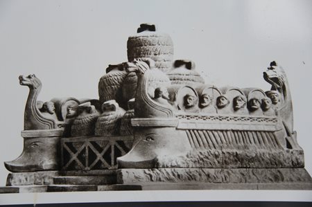
An artist's interpretation of the famous wine merchant's tomb found in Neumagen. Sections of this tomb still survive and are on display in Trier's, Landesmuseum.
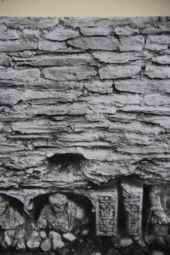
A photograph of a section of Neumagen's Gallo-Roman fort wall built in the early AD 4th century which clearly shows the recycling of stone funerary monuments (AD 1st-3rd centuries). Neumagen's famous stone monuments were probably taken from either Trier's cemeteries or the villas' private cemeteries.
The fort at Noviomagus was built by Emperor Constantine in the early 4th century AD. The original settlement of Noviomagus Treverorum was destroyed by Germanic raids circa. AD 275. Although relatively compact measuring 112 mtres x 131 metres, the fort had 13 round towers and two large gateways. The garrison's job was to protect the important junction and docking point where the road from Mainz to Trier meets the Moselle River.
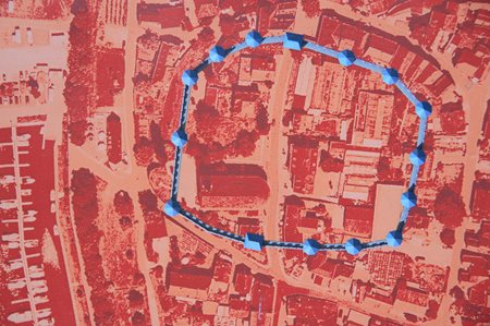
Basically the size of a small athletics track, Neumagen fort's foundations take up a few blocks of today's town. It is estimated that the fort's 500 men and animals would have consumed over a tonne of flour a day. A milestone dated AD 212 was found at Neumagen and inscribed with Emperor Caracalla's name and distance to Trier - 15 Gallic leugas = 2,200 metres x 15 = 33 kilometres.
In 1997, archaeologists discovered sections of tower P which was thought to have been demolished. Surprisingly, some sections of the tower's walls were 2 metres high. Another unusual find within this section of the tower P was a layer of recycled ashlar columns with semi-circular capping.

Now the most recently conserved section of the fort, tower P shows off its in situ ashlar columns.

A replica of the 'Leuga Stone' on a Neumagen's main street has the following inscription:
"To the commander and emperor
Marcus Aurelius Severus Antonius,
the pious and fortunate Augustus,
conqueror of Arabia's Adiabenes [Assyria].
the greatest triumpher over the Parthians and Britannia."
Emperor Constantine also experienced his Christian epiphany (according to his contemporary Eusebius) just above the Neumagen fort at Kronberg. He went on to a famous victory over his rival emperor, Maxentius at the Battle of Milvian Bridge in AD 312. The following year Constantine issued the Edict of Milan which legalised Christianity.
Another Neumagen funerary stone that sheds light on Gallo-Roman life is the so-called 'Paying of the Lease Relief'. In the relief rural tenant farmers are depicted grudgingly paying their taxes to fastidious Gallo-Roman or Treveri tribal officials who check every coin for defects.

Gallic farmers are wearing the 'caracallus' cloak or Celtic clothes which Emperor Caracalla wore on his Syrian campaigns. His 'barbarian' dress code encouraged his supporters to rename him Emperor 'Caracalla'. Note the Gallo-Roman official in the middle of the relief knocking back a coin from the bald-headed tenant farmer.
In 1990/91 two Gallo-Roman wineries were excavated on the vineyards of Braunberger Juffer-Sonnenuhr near Brauneberg. The eastern winery was dated to AD 250 with a western extension in the 4th century AD. The two wineries produced wine from the surrounding 30 hectares. Two top basins allowed for the crushing of grapes by foot and by pressing whilst the two lower basins collected the grape juice. Interestingly, elderberry pips were excavated revealing an inclusion of this fruit in the wine.
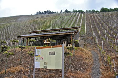
Brauneberg's Gallo-Roman winepress is the oldest on the Moselle (AD 250).
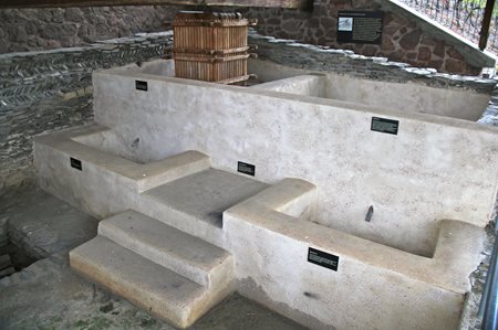
The basin on the top right holds 5 cubic metres of grapes and juice. The middle steps/platform as well as separate steps into the bottom right vat allowed easier access for workers to empty the wine into wooden barrels or ceramic containers for storage/shipment.
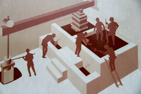
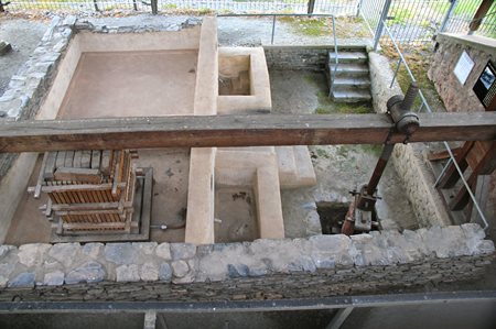
The winepress is still in use during the annual wine festival although a modern wooden winepress has replaced the original Gallo-Roman basketpress system.
The Roman writer, Columella in his book, De Re Rustica, which is in the form of a discourse with his friend Publius Silvinus, mentions three types of grapes grown in Gaul and adds that grapes grown on hills had the best flavour with northern slope grapes being more productive; yet, grapes grown on the southern slopes were far superior in quality.

A Gallo-Roman technique of staking grapevines on one stake either arched or S-shaped gave the impression of a figure 8 as depicted in this Neumagen funerary stone. One grape variety mentioned by Columella, Pliny the Elder and Macrobius that grew well along the Moselle was 'vitis albuelis' or 'vits alba'. It is still grown in a small 1000 hectares area along the Moselle at Elbling.
"Now, O Rhine, open your bosom, open your raiment[garment],
Your blue-green cloak to make space for new waters,[rivers],
Let yourself be swelled by a brother-stream[Moselle].....
....Yours is an eternal name.......
Rich in water, rich in nymphs, prodigal of both.
Your strength will grow, and the Franks will tremble at it.....
They will regard you as the true boundary of the empire."
- Ausonius, Mosella, 15 trans. David Parsons (May 2003)
Like Ausonius, a 4th century Gallo-Roman poet from Bordeaux, one can not help being awestruck when first sighting the mighty Rhine River. Throughout most of the Roman Imperial period it served as either a clear boundary between Roman Gaul and "the most savage nations of the Germans" (M. Tullius Cicero, Against Piso, 33) or as a backstop to a more proactive, militaristic German foreign policy such as the creation of the limes or boundary line consisting of a series of forward forts and watchtowers as well as a communication and trading pathway which was continuously developed from emperors Domitian to Hadrian (H. Schonberger, "The Roman Frontier in Germany: an Archaeological Survey." Journal of Roman Studies, vol.59, no.1/2, 1969).
The 65 kilometres stretch of the Rhine between Bingen and Koblenz, collectively called Upper Middle Rhine Valley, became a UNESCO Heritage Site in 2002. It is particularly famous for its 40 castles and fortresses that have dominated the Rhine over a 1000 year period. One Gallo-Roman fortress, which is often overshadowed by the more mythical, medieval castles/forts along the Rhine, is Boppard.
The Gallo-Roman origins of Boppard or Boudobrica (formerly a Celtic settlement called Baudobriga) have been somewhat controversial. Originally it was thought to have been constructed by Emperor Constantius I AD 286-306 (R.M.Butler, "Late Roman Town Walls in Gaul," Archaeological Journal, 116, 1959), due to the discovery of brick stamps from Legions XXII (Mainz) and VIII (Strasbourg) in the wall courses but most archaeologists now believe Boppard's origins to be circa.mid 4th century because of dating of pottery finds and changes to fortification design. H. Schonberger (1969) prefers Emperor Constantius II because of the change to the barracks' position within Boppard's traditional rectangular fort - barracks were built against the inner faces of walls rather than in the centre thus making forts safer from catching fire or bombardment. Its 28 semi-circular, horse-shoe shaped towers also help to date it c. AD 360. An alternative view is that Boppard was part of Emperor Valentinian 's massive reorganisation of Rhine defences c. AD 369. whereby the emperor supplemented and made more dense a system of fortifications to protect the roads and waterways from incursions by Franks and Alemanni tribes.
Some 600 auxiliary soldiers were stationed within Boppard's fort. It was 308 metres x 154 metres making a rectangle of 4.7 hectares. The walls were 9 metres high and its 28 watchtowers were spaced 27 metres apart. A bathhouse was one the largest constructions on the site.
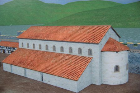
Boppard's bathhouse with a barracks in the left background positioned against an inner wall for more protection from attack.
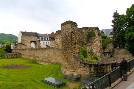
A small section of Boppard's Gallo-Roman fort remains well conserved. It was the strengthening of the Roman limes and forts like Boppard along the Rhine and Danube Rivers from the mid 4th century AD that enabled the Roman Empire to recover for several more decades from the serious raids/invasions from Germanic tribes since AD 259-260.
Mainz or Mogontiacum was always an important Roman legionary fort that initially deployed at least two legions. Between 15-10 BC Augustus was the first emperor to permanently station troops along the Rhine River. Along with Vetera I (near Xanten), Mainz with its XIV and XVI legions occupied a strategic position on the confluence of the Rhine and Main Rivers. Drusus, Livia's son and Augustus' stepson, marched north on his Germanic campaigns 10-9 BC from Mainz (H. Schonberger, "The Roman Frontier in Germany: An Archaeological Survey," Journal of Roman Studies, vol. 59, 1/2, 1969, p.144).
Build on the Kastrich plateau that overlooked both the Rhine and Main Rivers, Mainz's original 36 hectares fort soon stimulated changes providing important economic, political and social opportunities for neighbouring tribes including the introduction of imported cereal crops and fruits (H. von Petrikovits, "Fortifications in the North-Western Roman Empire from the 3rd to the 5th centuries AD," Journal of Roman Studies, vol.6, 1971, p.73). For a good palaeobotanic review of Vetera I's former silted-up harbour and what it revealed about Gallo-Roman agricultural changes see 'Der Xantenener Raum in der Antike' (click on Vegetation' ). Emperor Domitian created the two provinces of Germania Superior and Germania Inferior in AD 89 with capitals in Mainz (Mogontiacum) and Cologne (Colonia Claudia Ara Agrippinensium) respectively.
During the Julio-Claudian principate a defensive backbone began to take shape along the Rhine and Danube Rivers albeit involuntarily rather than based on a preconceived defensive 'grand stategy'. However, the end evolutionary result based on decades of emperors' inputs and largely an inability to tame the Germanic tribes was the formation of the 'limes' or defensive boundary path that extended over 550 kilometres comprising over 120 forts of various sizes and approximately 900 watchtowers. Some 110,000 soldiers concentrated at one time along the limes must have had a "profound" impact on the various regions it spanned (P.S. Wells, The Barbarians Speak, (New Jersey, 1999, pp13-14, p.91).
Although Mainz is just fractionally south of the UNESCO's World Heritage Site - The Upper Middle Rhine Valley (AD 2002), the fort and the town that soon developed close to it, did play a very important role in the Gallo-Roman era especially in helping to provision troops stationed along the 'limes' (P.S. Wells, Ibid., p.174). It is likely that the increased demand for consumer goods by these military centres encouraged the rapid growth of villas, at first in the immediate vicinities; then, throughout greatly extended areas (P.S.Wells, "Creating an Imperial Frontier: Archaeology of the Formation of Rome's Danube Borderland," Journal of Archaeological Research, vol 13, no.1 (March 2005), pp.64-65.
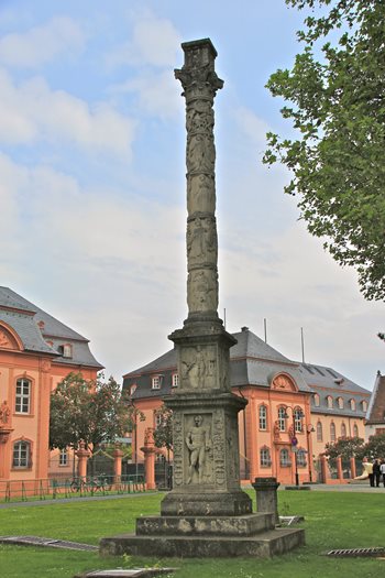
One of the best known Jupiter columns in the Rhineland is this Neronian monument (c.AD 54-68) at Mainz. Jupiter columns are "ubiquitous" in the Rhineland with over 40 produced in Mainz alone creating a Manhattan skyscraper landscape. A total of 550 Jupiter columns have been found representing the most common form of religious monument in the Rhineland during the 2nd and early 3rd centuries. The Jupiter columns were usually part of a small votive offering area that publicly demonstrated loyalty to the emperor and Rome within a 'new order' of Roman provinces (G.Woolf, "Representation as cult: the case of Jupiter columns,"in W. Spickermann's, Religion in den germanischen Provinzen Roms, Tubingen, 2001, pp.118-120).
Discovered in 1905 during construction work, the Mainz Jupiter Column was found broken into 2,000 parts and deliberately buried. Its 5 stone drums column measures 9.14 metres high and has 28 Gallo-Roman deities sculptured around its column and base. More importantly, it also has an inscription, one of some 250,000 from the Roman World, dedicated surprisingly to Emperor Nero although it has evidence of 'damnatio memoriae' - an obliterating line through the emperor's name!
"To Jupiter, greatest and best,
for the health of Nero
Claudius Cae...
sar Augustus, imperator,
by the cannabae community [merchants/traders].
Publius Sulpicius Scribonius
Proculus was governor
Made and paid for by
Quintus Julius Priscus
Quintus Julius Auctus [2 decuriones?]

A replica of a rare Neronian dedicatory inscription from Mainz's Jupiter Column revealing a "culture of loyalism" towards the new Imperial regime among its indigenous merchant subjects (G. Rowe, Princes and Political Cultures: The New Tiberian Senatorial Decrees, Michegan, 2002). Ironically, it was after Nero's demise in AD 68 that civil war broke out along the Rhineland forts, a reminder that political consensus within the new regime was fragile.
Another interesting discovery in Mainz occurred in the 1970's with the unearthing of Europe's oldest Mithraeum. Although it was sadly destroyed in 1976 by construction workers, amateur archaeologists managed to salvage 601 finds, mostly pottery sherds, enough to help date the temple to AD 69-75. One of the saved pottery pieces called Wetterau ware, measured 40 cms. high and along with a snake motive, the vessel had an inscription on it entitled, 'Quintus Cas[sius]'. Roger Beck (2000) believes Mithraism, like Christianity, promised salvation and an egalitarian access to a type of heaven. Beck also raises the long-shot possibility that Nero's self-identification and promotion of the Sun cult may have provided the fashion for Mithraists to continue into the future (Roger Beck, "Ritual, Myth, Doctrine and Initiation in the Mysteries of Mithras: New Evidence from a Cult vessel," Journal of Roman Studies, vol 90, Nov. 2000, p.167).
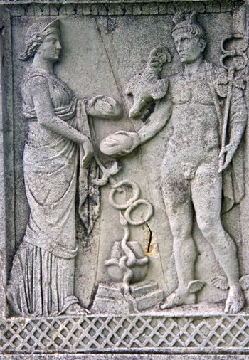
Donated by the local merchants of Mainz, the Jupiter Column pays syncretic homage to Mercury, god of commerce, and Rosmerta, the 'Great Provider' (a Gaulish goddess of abundance who is often associated with Mercury).